

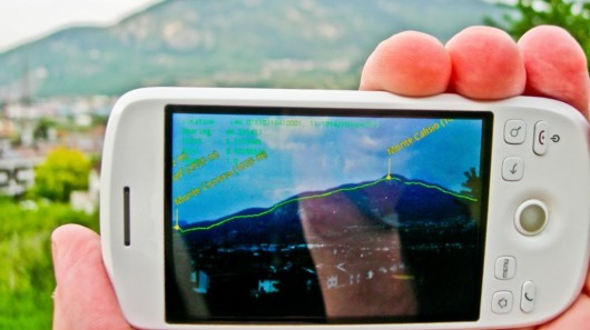

There is no dearth of super silly apps but once in a while you do come across really interesting and useful ones. Marmota mobile augmented reality designed by Michele Zanin, Claudio Andreatta and Paul Chippendale, researchers at the Technologies of Vision Unit (TeV) in the Information Technology Centre of Fondazione Bruno Kessler (FBK) in Trento, Italy falls in the latter category. This app especially targets folks thoroughly fond of knowing each and everything when it comes to topographic details. Once activated by a user, the device locates itself with a built-in GPS, then sends information via the Internet to the central Marmota server at FBK. The information processed is sent as a data package of about 50 to 120 KB to the device, and displayed as a high-resolution 360-degree augmented onscreen overlay. Besides giving vital info on mountains such as their altitude, latitude, longitude and distance from the observer, the app also provides names and locations of counties, roads, hiking trails, rivers and lakes, and what not related to topography.
Via: Gizmag